Maps show land and water. A map will show
you where a lake is located
and where a river begins and ends. The Great Lakes are in the United
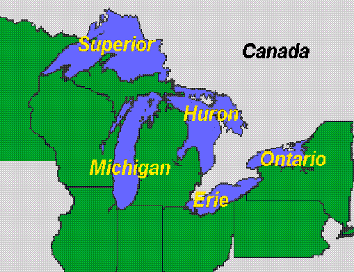
States. The five great lakes are Huron, Ontario, Michigan, Erie, and Superior. (HOMES)
Use the map below to complete the questions.
1. What lake is north of Lake Michigan?
Lake Ontario
Lake Erie
Lake Superior
None of the above.
2. How many lakes border Canada?
One
Two
Three
Four
3. How many states border Lake Ontario?
One
Two
Three
None
4. How many states border Lake
Superior?
One
Two
Three
None
5. How many states border Lake Michigan?
One
Two
Three
Four
6. What state has borders on Lake Superior, Lake Michigan, Lake
Huron, and Lake Erie?
Elementary & Middle School Lessons & Self-Correcting Tests for Children in all Subject Areas. If you have found an error or would like to make comments on this lesson,
please email us at:
MySchoolhouse.online@gmail.com
Copyright 1999-2024 by Educational Designers, LLC. All rights reserved. Lessons & Tests in Math, Reading, Spelling, Science, Language, and Social Studies.
"This site uses cookies from Google to deliver its services and analyze
traffic. Your IP address and user-agent are shared with Google along with
performance and security metrics to ensure quality of service, generate
usage statistics, and to detect and address abuse."