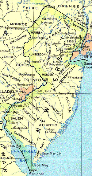
Political maps show boundaries of countries,
states, counties and provinces. A political map also shows the
location of cities. Look at the political map of New Jersey below.
Use the map above to answer the following questions.
The capital of a state is usually represented by a
star. What is the capital of New Jersey?
States are usually divided into counties. What
county lies at the southern most tip of New Jersey?
What city in Burlington County is south of
Trenton?
What county borders the east side of Hunterdon
County?
Starting in the north, list the five counties that
border the Atlantic Ocean.
What city is directly east of Mt Holly?
What is the northern most city in New Jersey listed on
the map?
What is the western most city in New Jersey listed on
the map?
What bay borders New Jersey's southern border?
Bay.
Elementary & Middle School Lessons & Self-Correcting Tests for Children in all Subject Areas. If you have found an error or would like to make comments on this lesson,
please email us at:
MySchoolhouse.online@gmail.com
Copyright 1999-2024 by Educational Designers, LLC. All rights reserved. Lessons & Tests in Math, Reading, Spelling, Science, Language, and Social Studies.
"This site uses cookies from Google to deliver its services and analyze
traffic. Your IP address and user-agent are shared with Google along with
performance and security metrics to ensure quality of service, generate
usage statistics, and to detect and address abuse."